An unusual topic but one that most yachtsmen with navigational skills will understand?
This subject came up when a discussion was in place on GPS and how to place your position on land? in my case its specific to the Western Cape and South Africa, heritage here dates to the rule of Great Britain, so I expect its the same over there now also?
Justin, your own survey work has just reminded me of when we took title of this plot Erf 3++9 we were actually shown and sold the one next door by the sales agent, thats to the left when looking at the house.

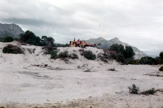
The start of the site leveling, we were 'sold' the plot to the left of the green service box.
The plots then were all were covered by mountains of sand, similar to those at the old HBYC now
http://ckdboats.blogspot.com/2013/01/a-new-discovery-lost-hbyc-club-house-is.html
and to the seaward side of the plots, I wanted to use a John Deer front end loader to move the sand and then level the plot, that took two days on a plot of less than 900 square meters.
 High up on what was actually some other persons plot, we were pulling that sand back to our plot to raise our own. All Plant Hire did a good job, the invoice being for R500.00.

We booked the machine but before it arrived I decided to check the survey map, I needed a long steel tape, 50 mtrs type, then looking at all the numbers on the survey I realised I was looking a compass bearings! I then used my hand bearing compass from the boat, deducted the variation and soon found out where my corner pegs should be.
This was a big job, it took two days and Jean and I got our monies worth!
I then discovered that we were about to clear the wrong plot and when I did survey the right one, I found our corner peg where the side lane is was at the road and not 1.5 meters further back!

Jean with baby Janet at the end of the clearing work. Janet was six months old then, she is now thirty and has just produced her second son to husband Nigel. They are planing on building their own home this year but bought a nice level plot!
I assume todays surveys are all GPS driven, whats on your plot survey?
Your mail re GPS survey message is below.
I have also used the averaging techniques he mentions for surveying, albeit in recent times with far greater accuracy – but I got readings down to about 30cm
A second mail on the same topic and very good advice!
Hi Roy,
That’s a great story. No todays surveys are not GPS driven at all. They still use the standard reference beacons, sights and bearings, although there are lots of nice tools that make it easier – especially laser sights etc etc, and things that can do. GPS is just for informal stuff….and certainly should not be used for altitudes under any circumstances.
Justin.
Thinking about the option to move to a GPS position maping of land made me realise the total (absolute) folly of such an idea, the old method with compass bearings is as secure as navigation has been untill the GPS came along but what happens when the GPS signals fail, or indeed if the USA decides to switch the signals off, then what!
No, surveyors still have a good future, I guess the compass bearings and an added GPS position make sense but the compass card will always have the first choice.
Another blog by Roy McBride ( own land surveyor)
Building on sand, is it a good idea?
More on the subject will follow in another edition of this blog.
This subject came up when a discussion was in place on GPS and how to place your position on land? in my case its specific to the Western Cape and South Africa, heritage here dates to the rule of Great Britain, so I expect its the same over there now also?
Justin, your own survey work has just reminded me of when we took title of this plot Erf 3++9 we were actually shown and sold the one next door by the sales agent, thats to the left when looking at the house.

The plots then were all were covered by mountains of sand, similar to those at the old HBYC now
http://ckdboats.blogspot.com/2013/01/a-new-discovery-lost-hbyc-club-house-is.html
and to the seaward side of the plots, I wanted to use a John Deer front end loader to move the sand and then level the plot, that took two days on a plot of less than 900 square meters.

One of the nicer hand bearing compasses to use, at the time the magnetic variation was 23 degrees west, that had to be deducted from the reading on the compass card to find the actual true reading which was on the survey map.
We booked the machine but before it arrived I decided to check the survey map, I needed a long steel tape, 50 mtrs type, then looking at all the numbers on the survey I realised I was looking a compass bearings! I then used my hand bearing compass from the boat, deducted the variation and soon found out where my corner pegs should be.
This was a big job, it took two days and Jean and I got our monies worth!
I then discovered that we were about to clear the wrong plot and when I did survey the right one, I found our corner peg where the side lane is was at the road and not 1.5 meters further back!
August 1983
Jean with baby Janet at the end of the clearing work. Janet was six months old then, she is now thirty and has just produced her second son to husband Nigel. They are planing on building their own home this year but bought a nice level plot!
I assume todays surveys are all GPS driven, whats on your plot survey?
Your mail re GPS survey message is below.
I have also used the averaging techniques he mentions for surveying, albeit in recent times with far greater accuracy – but I got readings down to about 30cm
A second mail on the same topic and very good advice!
Hi Roy,
That’s a great story. No todays surveys are not GPS driven at all. They still use the standard reference beacons, sights and bearings, although there are lots of nice tools that make it easier – especially laser sights etc etc, and things that can do. GPS is just for informal stuff….and certainly should not be used for altitudes under any circumstances.
Justin.
Thinking about the option to move to a GPS position maping of land made me realise the total (absolute) folly of such an idea, the old method with compass bearings is as secure as navigation has been untill the GPS came along but what happens when the GPS signals fail, or indeed if the USA decides to switch the signals off, then what!
No, surveyors still have a good future, I guess the compass bearings and an added GPS position make sense but the compass card will always have the first choice.
Another blog by Roy McBride ( own land surveyor)
Building on sand, is it a good idea?
More on the subject will follow in another edition of this blog.


